Soñar no cuesta nada, y Querer es poder!
Capital Beltway punto com
Sitio web para la Capital Beltway Highway Proyectos!
La Circunvalación de la Capital es la autopista Interestatal 64 kilómetros de largo que rodea Washington, DC, pasando por Virginia y Maryland, que lleva la carretera interestatal I-495 a lo largo de la designación, y llevar a la superposición de la Interestatal I-95 la designación en la porción oriental de la carretera de circunvalación.
A continuación se presenta una lista de artículos con enlaces desde este sitio:
Washington, DC Area
Capital Beltway (I-495 y I-95)
Capital Beltway Historia
Springfield Proyecto de Intercambio
Springfield Intercambio Fotos del Proyecto
Woodrow Wilson Bridge (I-495 y I-95)
Puente Woodrow Wilson - Construcción
Woodrow Wilson Bridge Project Fotos
Intercounty Conector (ICC)
Washington Outer Beltway
Estudios Bypass Washington
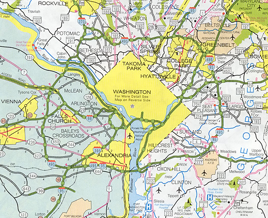
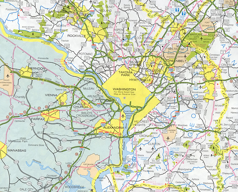
| Capital Beltway (I-495 and I-95) |
 | The Capital Beltway is the 64-mile-long Interstate freeway that encircles Washington, D.C., passing through Virginia and Maryland, carrying the Interstate I-495 designation throughout, and carrying the overlapping Interstate I-95 designation on the eastern portion of the Beltway. |  |
 | Capital Beltway is I-495, from MDOT SHA 2000 state map. Larger images - medium (235K), and large (469K). |
The name of this freeway while it was still in the planning stages in the 1950s was the Washington Circumferential Highway. Formal planning for the Beltway began in 1950, and it was included as part of the 41,000-mile national Interstate Highway System in the Federal Aid Highway Act of 1956, and construction of the highway began in 1955. The highway was officially named "Capital Beltway" by actions of Maryland and Virginia officials in June, 1960, and that has been the official name since then.
The I-495 Capital Beltway was fully completed when its final segment was opened to traffic on August 17, 1964. I-495 is 64 miles long; with 22 miles in Virginia, and 42 miles in Maryland. When opened, road was four lanes wide (two each way) for 14 miles between I-95 at Springfield, Virginia, and the American Legion Memorial Bridge over the Potomac River near Cabin John, Maryland. The Legion Bridge and the remaining 50 miles of the Beltway had six lanes (three each way).
For more Capital Beltway historical details, see Capital Beltway dot com article:
Capital Beltway History.
Capital Beltway dot com is the Capital Beltway annex to Roads to the Future.
In the span of 1972 to 1992, nearly the entire Beltway was widened to eight lanes (four each way). In 1972, Maryland completed Beltway widening to eight lanes (four each way) between MD-210 Indian Head Highway and MD-97 Georgia Avenue, a distance of 29 miles. In 1977, Virginia completed Beltway widening to eight lanes between US-1 Jefferson Davis Highway and VA-193 Georgetown Pike, a distance of 21 miles. In 1990, Maryland completed Beltway widening to eight lanes between MD-97 Georgia Avenue and I-270/MD-355, a distance of 4 miles. In 1991-92, Maryland and Virginia completed Beltway widening to eight lanes between I-270 Spur and VA-193, a distance of 5 miles; this included the American Legion Memorial Bridge and approaches to each interchange closest to the river, which was widened to 10 lanes. The 3 miles of Beltway between I-270/MD-355 and I-270 Spur is adequate at six lanes, as the traffic volume is about 1/2 of that of the adjoining sections of the Beltway.
No comments:
Post a Comment